

MEGAPHAT METRO® - VIRTUAL LINK SURVEYOR
The world has gone nuts for wireless networking and why not? Wireless is everywhere, it's easy and becoming more affordable! FIxed-wireless offers flexibility away from legacy technologies such as copper and fiber. All you need is 2 radios, the AP and the Station!
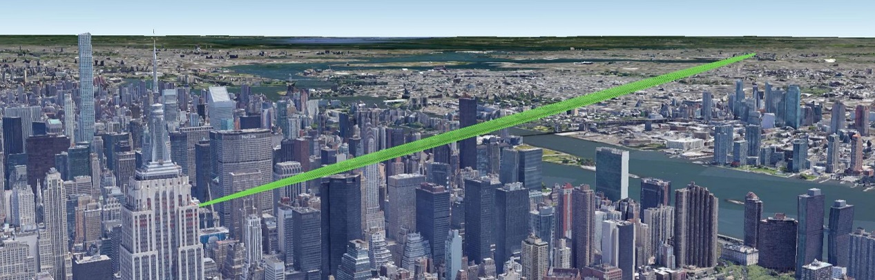
While wireless is growing more and more and in many cases you don't need to have a license, one of the difficult hurdles of integrating wireless into your infrastructure is how to make it work.Sometimes you may be lucky enough to use Google Earth to simulate your wireless link but in Metropolitan areas such as New York City, you may be in for more challenges than you're expecting.
Megaphat Metro® helps to alleviate these challenges by creating virtual sites and generating link information. Just because you can see the building doesn't mean your link will work. Megaphat Metro® helps you understand why. Megaphat Metro® is capable of analyzing links from 900Mhz to 80Ghz which offers a broad range of bands.
You simply create the sites you wish to connect wirelessly, select from a choice of radios or even create your own radio type, then click to create a wireless link! Megaphat Metro® will create a virtual link survey using a combination of proprietary and open GIS data sources which will include ground elevations and building heights (building heights are only available for the NYC area), perform all necessary calculations and provide you a comprehensive link analysis. you can even export the report to PDF! Additionally if you use Google Earth or ArcGIS you can import from Megaphat Metro® to create a stunning visualization where you can fly-through the entire distance of the link to determine link potential.
|
✓ Create Customers ✓ Create Customer Sites ✓ Export Single Site KML ✓ Export All Customer Sites KML ✓ Create Links Between 2 Sites ✓ Add Custom Radios Configurations ✓ Use Existing Radio Configuration Database ✓ View Distance Markers in KML ✓ Enable/Disable visible Fresnel Zones in KML ✓ Enable/Disable visible Signal Line of Sight in KML ✓ Click to view buildings in KML (NYC Only) ✓ Show/hide building polygons in KML (NYC Only) ✓ View Link Distance ✓ View Link Midpoint Distance |
✓ View Link Maximum 60%, 80% and 100% Fresnel Zone Radius ✓ View Link Free Space Path Loss ✓ View Link Maximum Horizon ✓ View Site-A and Site-Z Maximum Horizon ✓ View Link RSSI Budget ✓ View Link Midpoint Coordinates ✓ View Link Site-A and Site-Z information ✓ View Link Altitude/Elevation Difference ✓ View Link Forward Bearings (Azimuth from Site-A) ✓ View Link Reverse Bearings (Azimuth from Site-Z) ✓ View Link Forward Elevation (Site-A Antenna Elevation) ✓ View Link Reverse Elevation (Site-Z Antenna Elevation) ✓ View Link Distance Analysis ✓ View Link Obstruction Analysis |
Megaphat Metro® is not a replacement for physical site surveys but it is a quick and less expensive means perform link viability assessments. This means you can save time and money by having a virtual survey performed before committing resources to a physical survey.
Currently Megaphat Metro® is in Beta and only available to beta participants. You can request beta access by providing your email address